
By default once you log into the fleetdynamics portal you will be displayed the "Live tracking" screen. This screen is designed to allow live monitoring of vehicles location and vehicle behavior.
Map style
Fleetdynamics uses fully licensed Google maps interface to overlay your GPS data on, this means you have full access to all the standard Google maps features you will be used to such as;
- Map View
- Satellite View
- Street View
You can change between these modes by utilizing the icons located in the right hand side of the map.
Vehicle data
Your vehicles are overlaid on the map as both a user defined icon [default: Yellow pushpin] and a label containing the vehicles registration that is fixed to the bottom right of your chosen marker icon.
By clicking on any of your vehicle's icon, the system will display the current data available for the vehicle in a information window. This information will be updated when the vehicles ignition is switch on, every 30 seconds while in motion, when the vehicle's direction changes greater than 20 degrees or when the ignition is switched off. If the vehicle is not turned on this information will update on ignition off, and every 12 hours thereafter.
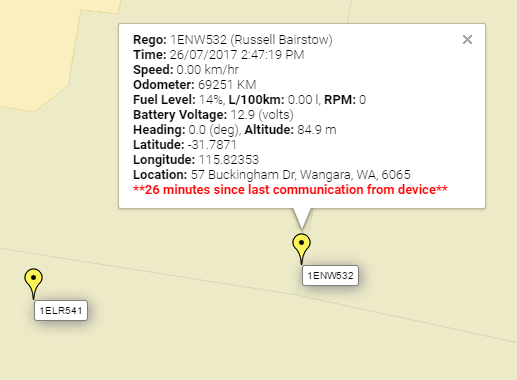
If the vehicle has been stationary for a period of time greater than 10 minutes, the information window will also display how long the vehicle has been sitting idle/stationary.
Link: What do the various colors on the portal mean?
Other functionality
In addition to viewing the vehicles current location, you can also use the live tracking screen to perform various other functions within the system:
- Adding, editing and removing POI's
- Locating closest vehicle to location
- Searching street address
- Adding, editing and removing polygon Geofence to map
Comments
0 comments
Please sign in to leave a comment.